\
&
Contact us
\
&
Contact us
\
&
Contact us
\
&
Contact us
This was 1 year ago
LocationOnline
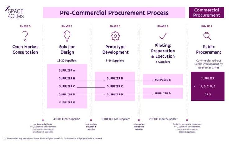
ProgrammesEarly next year, District09 will launch a European tender with 4 partner cities for companies that work with satellite data. There is 2.87 million euros available in 3 rounds, but registering in the first round is crucial.
The SPACE4Cities project focuses on developing smart solutions for the dynamic management of urban space using European satellite data. District09 works closely with four partner cities: Forum Virium Helsinki, the Municipality of Amsterdam, the Municipality of Guimarães and Innovation Attica. Together they are making 2.87 million euros available, spread over three rounds. The tender offers innovative companies the opportunity to participate and develop new solutions. Registration in the first round is essential for full participation in the program.
District09 is organizing a webinar together with the City of Ghent to explain the challenges they want to tackle in this call. These include urban development interventions, climate adaptation and the maintenance of public space. They will also explain in detail how you can register and what the further procedure is. This is therefore a warm call to Flemish companies to attend this webinar and register for the public tender when it is launched.
We offer news and event updates, covering all domains and topics of Horizon Europe, Digital Europe & EDF (and occasionally, for ongoing projects, Horizon 2020).
Stay informed about what matters to you.
By signing up, you can opt in for e-mail notifications and get access to
a personalised dashboard that groups all news updates and event announcements in your domain(s).
Only for stakeholders located in Flanders
GenderSAFE, funded by Horizon Europe under call topic HORIZON-WIDERA-2023-ERA-01-09, is a project that advances efforts to implement a zero-tolerance approach to gender-based violence in higher education and research in the European Research Area. This overall objective will be achieved through a five-fold strategy. The project exists of a European-wide consortium of six partners. Read more about the GenderSAFE’s five-fold strategy, the role of the Belgian partner Yellow Window and the latest outputs of the project in this testimonial.